Object
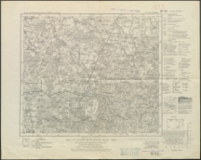
Title: Nordenburg. Karte des Deutschen Reiches. 76
Rodzaj dokumentu:
Temporal coverage:
Description:
Place of publishing:
Publisher:
Date created:
Date issued:
Format:
Identifier:
Language:
Rights:
Access rights:
Digitisation:
Wojewódzka Biblioteka Publiczna w Olsztynie
Location of original object:
Polskie Towarzystwo Turystyczno-Krajoznawcze w Olsztynie
Object collections:
- Warmia-Mazury Digital Library
- Warmia-Mazury Digital Library > Institution collections > Polskie Towarzystwo Turystyczno-Krajoznawcze w Olsztynie
- Warmia-Mazury Digital Library > Institution collections > Polskie Towarzystwo Turystyczno-Krajoznawcze w Olsztynie > Maps and atlases
- Warmia-Mazury Digital Library > Forms of resources > Mapy i atlasy
Last modified:
Oct 17, 2017
In our library since:
Mar 22, 2017
Number of object content hits:
159
All available object's versions:
https://wmbc.olsztyn.pl/publication/4710
Show description in RDF format:
Show description in OAI-PMH format:
| Edition name | Date |
|---|---|
| Nordenburg. Karte des Deutschen Reiches. 76 | Oct 17, 2017 |


